
Clark County ZIP Coverage
Clark County's official boundary map provides an orientation layer for ZIP research. It labels polygons across the Las Vegas Valley, incorporated cities, rural communities, and mountain or edge areas. Postal places and delivery stations are not the same thing as city boundaries, and the research did not locate a complete official USPS ZIP-to-post-office crosswalk for every county label. The table keeps the post-office field explicit so that an exact USPS result is obtained before it is treated as a postal fact.
| ZIP | Areas Covered | Post Office | Notes |
|---|---|---|---|
| 89002 | Henderson, southeast valley | Verify in USPS Cities by ZIP | Confirm parcel city and Henderson jurisdiction. |
| 89005 | Boulder City and Lake Mead area | Verify in USPS Cities by ZIP | Check for Boulder City, adjacent federal, or rural land. |
| 89019 | Goodsprings-Primm rural corridor cue | Verify in USPS Cities by ZIP | Large rural area. Use exact coordinates and APN. |
| 89027 | Mesquite, northeast county | Verify in USPS Cities by ZIP | Confirm the city boundary before routing a request. |
| 89029 | Laughlin and Colorado River area | Verify in USPS Cities by ZIP | Use the parcel and Laughlin community route. |
| 89040 | Moapa, northeast county | Verify in USPS Cities by ZIP | Community context is not a resident roster. |
| 89101 | Central Las Vegas and downtown | Verify in USPS Cities by ZIP | Historic address sources can be especially useful. |
| 89106 | West-central Las Vegas, Historic Westside cue | Verify in USPS Cities by ZIP | Use the official survey and city timeline for history. |
| 89124 | Mount Charleston and Spring Mountains | Verify in USPS Cities by ZIP | Use exact parcel and community checks for rural addresses. |
| 89148 | Southwest valley, city and Enterprise layers | Verify in USPS Cities by ZIP | Confirm the parcel and community-board area. |
| 89161 | Red Rock-Blue Diamond rural cue | Verify in USPS Cities by ZIP | Keep rural and community context distinct. |
| 89183 | South valley | Verify in USPS Cities by ZIP | Use APN and current GIS before selecting an agency. |
These rows are researched starting points, not a post-office directory. The county map and GIS are the geographic sources; the USPS postal lookup supplies its own address-standardization and Cities by ZIP modes. A USPS result does not confirm that a person or organization is at an address.
Clark County ZIP Map Labels
The Clark County ZIP boundary map is dated April 19, 2025. It is a display and planning aid, not a delivery-route guarantee or a municipal-boundary map. The inspected label list is: 89002, 89004, 89005, 89007, 89011, 89012, 89014, 89015, 89018, 89019, 89021, 89025, 89027, 89029, 89030, 89031, 89032, 89034, 89039, 89040, 89044, 89046, 89052, 89054, 89074, 89081, 89084, 89085, 89086, 89087, 89101, 89102, 89103, 89104, 89106, 89107, 89108, 89109, 89110, 89113, 89115, 89117, 89118, 89119, 89120, 89121, 89122, 89123, 89124, 89128, 89129, 89130, 89131, 89134, 89135, 89138, 89139, 89141, 89142, 89143, 89144, 89145, 89146, 89147, 89148, 89149, 89156, 89161, 89165, 89166, 89169, 89178, 89179, and 89183.
The county's free GIS maps add incorporated-city, unincorporated-town, street-centerline, precinct, district, school, and TAB/CAC layers. Use the map date in a research note, especially where a subdivision, boundary, or street designation may have changed.
Note: A ZIP polygon is a geographic reference, so keep the map date with any conclusion based on its boundaries.
Clark County ZIP Geography by Municipality
Clark County includes the incorporated cities of Las Vegas, Henderson, North Las Vegas, Boulder City, and Mesquite, plus unincorporated communities and rural areas. The same postal label can meet a city boundary, an unincorporated-town layer, a TAB/CAC area, or a different assessor situs. For example, grouped postal cues place Henderson ZIPs around 89002, 89011, 89012, 89014, 89015, 89052, 89054, and 89074, while the North Las Vegas group includes 89007, 89030, 89031, 89032, 89081, 89084, 89085, 89086, and 89087. Each still needs a parcel-level check.
Rural labels deserve more care. The county's research table points to Goodsprings-Primm for 89019, Moapa or Moapa Valley cues for 89021, 89025, and 89040, Mount Charleston for 89124, and Red Rock-Blue Diamond for 89161. Rural ZIPs can cover multiple named communities and large unincorporated areas. Coordinates, the APN, legal description, and the relevant community board are more reliable than a postal-city string.
Clark County ZIP Geocoding and APNs
The Clark County Composite ZIP GeocodeServer accepts a Street and ZIP field or a single-line input. Its candidate response can include score, matched address, address type, street components, city, county, state, ZIP, coordinates, and bounds. Use that response to validate a candidate address, then confirm the parcel with the Clark County Assessor Property Search and the parcel map.
The image from the Composite ZIP GeocodeServer represents the official geocoding route used to check a Clark County geographic lookup.
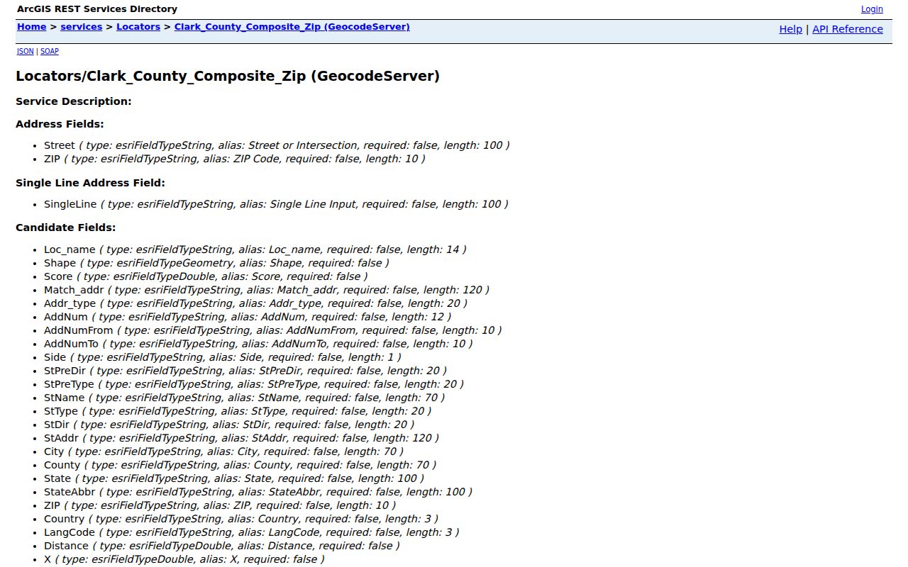
The matched candidate is an address-normalization lead. It cannot establish who lives there, how long they have been there, or which agency has the record. The APN is the stable bridge to the assessor, map, recorder, permit, and city-boundary checks.
A parcel map is not a legal survey. When legal boundaries or a recorded description matter, compare the relevant recorded map or document rather than relying on a generalized GIS display.
Finding Residents Within a Clark County ZIP
Use one ZIP as a narrowing field only after the address has been standardized. The assessor's Real Property Records page lists parcel number, owner, address, subdivision, subdivision owners, parcel type or book-page, parcel tree, and parcel-map inquiry routes. Its screenshot-capture record identifies address and ZIP as a search cue, but live fields can change, so inspect the current portal before relying on a filter.
- Enter the whole known address in the USPS tool and county geocoder, then save the standardized result and candidate ZIP.
- Use the matched address in the Assessor search to identify the APN, situs, map, and displayed ownership fields.
- Compare the APN in AssessorMap with ZIP, city, unincorporated-town, and TAB/CAC layers.
- Use the appropriate custodian for a related record after the parcel confirms the jurisdiction.
- Keep the ZIP as a correlation field when comparing a dated directory, newspaper, or election file, never as proof of residence.
The Election Department voter-list data files are available by district and status, while its walking-list material is address research. Those files are not a complete population count and omit confidential fields. Once a ZIP has narrowed the area to a particular street, the Clark County street directory provides the address-focused route.
Note: A ZIP match can support a record comparison, but it cannot replace an address, APN, date, and identity check.
Clark County ZIP Search Fields
ZIP research uses several official tools with different fields and different limits. The table distinguishes an address-normalization result from a parcel record or a postal-place query. It also shows why a one-field match should be corroborated before it is used for family history, civic research, or a property trail.
| Composite ZIP GeocodeServer | Street and ZIP, or single line; response may include match score, street parts, city, county, ZIP, coordinates, and bounds. |
|---|---|
| USPS postal lookup | Address, city/state, or ZIP; provides address standardization and Cities by ZIP modes. |
| Assessor Real Property Records | Parcel number, owner, address, subdivision, subdivision owners, parcel type/book-page, parcel tree, and map inquiry. |
| AssessorMap | Query, identify, find, map, and export operations for lotlines, parcels, and easements. |
| Voter-list data files | District and All, Active, or Inactive status selections. The registration lookup is identity-authenticated, not a public name-only search. |
If an online portal fails, redirects, or requires a session, preserve the official landing URL and contact the relevant office. GISMO lists 702-455-3855 and GISMO@ClarkCountyNV.GOV, while the Assessor lists 702-455-3882. The county's map layers also have limits such as display generalization and service downtime.
ZIP Boundaries and Clark County City Limits
ZIP boundaries and city limits solve different problems. A postal ZIP can cover city and unincorporated land, while an incorporated city maintains its own municipal court, permit, licensing, or clerk records. Clark County's public-records guidance specifically warns that the county is not the custodian for every record created within its geographic boundary. Match the address to the parcel and responsible agency before making a request.
- ZIP versus ZIP+4
- A five-digit postal area versus the added delivery detail used for a smaller segment of that area. Neither is a municipal boundary.
- PO-box ZIP
- A ZIP used for post-office boxes. The research did not identify a complete county-wide set of these, so verify an exact result with USPS.
- Unique ZIP
- A ZIP assigned to a single institution or large recipient. Do not assume one from a county map label without USPS confirmation.
- Carrier route
- A delivery grouping used by the postal service. It is not a parcel, city, neighborhood, or resident list.
Note: Use the postal result, parcel record, and jurisdiction layer together before drawing any conclusion from a ZIP.
Clark County ZIP Research Limits
The county publishes a 2024 postal population PDF, which is the correct official source for complete ZIP-by-ZIP population values. The research captured examples for 89002, 89005, 89011, 89012, 89014, 89015, 89104, and 89121, but it did not transcribe the full table. Those published values are ZIP estimates or counts, not a directory of people.
Historical sources may show a different ZIP because postal codes, road names, or address forms changed. Check the publication date, street form, and mapped location before calling that a move. A blank result also is not a negative fact until spelling, date coverage, custodian, technical status, and any confidentiality limit have been checked. Nevada NRS Chapter 239 generally opens public records during office hours unless a law makes them confidential, but each custodian controls its own records and access method.